Mercer County, New Jersey
| Mercer County, New Jersey | ||
|
||
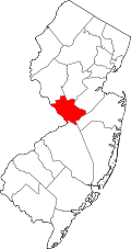 Location in the state of New Jersey |
||
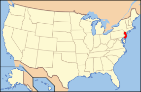 New Jersey's location in the U.S. |
||
| Founded | 1838 | |
|---|---|---|
| Seat | Trenton | |
| Largest city | Hamilton | |
| Area - Total - Land - Water |
229 sq mi (593 km²) 226 sq mi (585 km²) 3 sq mi (8 km²), 1.27% |
|
| PopulationEst. - (2006) - Density |
367,605 1,551/sq mi (599/km²) |
|
| Website | www.mercercounty.org | |

Mercer County is a county located in the U.S. state of New Jersey. Its county seat is Trenton, the state capital[1]. It is officially part of both the New York metropolitan area and the Trenton-Ewing Metropolitan Statistical Area. Unofficially, it is considered part of the Delaware Valley. As of 2007, the Trenton-Ewing MSA is ranked 136th in the list of U.S. Metropolitan Statistical Areas for total population at 365,449.
The county is named for Continental Army General Hugh Mercer, who died at the Battle of Princeton in 1777. The Mercer Oak, against which the dying general rested as his men continued to fight, appears on the county seal. As of the United States 2000 Census, the population was 350,761, estimated to have risen to 367,605 as of 2006.[2] Mercer County ranks 79th among the highest-income counties in the United States. It also is ranked 57th in the United States by per capita income.[3]
Mercer county is home to Princeton University, Princeton Theological Seminary, the Institute for Advanced Study, Rider University, The College of New Jersey, Thomas Edison State College and Mercer County Community College.[4]
Contents |
Demographics
| Historical populations | |||
|---|---|---|---|
| Census | Pop. | %± | |
| 1840 | 21,502 |
|
|
| 1850 | 27,992 | 30.2% | |
| 1860 | 37,419 | 33.7% | |
| 1870 | 46,386 | 24.0% | |
| 1880 | 58,061 | 25.2% | |
| 1890 | 79,978 | 37.7% | |
| 1900 | 95,365 | 19.2% | |
| 1910 | 125,657 | 31.8% | |
| 1920 | 159,881 | 27.2% | |
| 1930 | 187,143 | 17.1% | |
| 1940 | 197,318 | 5.4% | |
| 1950 | 229,781 | 16.5% | |
| 1960 | 266,392 | 15.9% | |
| 1970 | 304,116 | 14.2% | |
| 1980 | 307,863 | 1.2% | |
| 1990 | 325,824 | 5.8% | |
| 2000 | 350,761 | 7.7% | |
| Est. 2006 | 367,605 | [2] | 4.8% |
| historical census data source: [5][6] | |||
As of the census[7] of 2000, there were 350,761 people, 125,807 households, and 86,303 families residing in the county. The population density was 1,552 people per square mile (599/km²). There were 133,280 housing units at an average density of 590 per square mile (228/km²). The racial makeup of the county was 68.48% White, 19.81% Black or African American, 0.20% Native American, 4.94% Asian, 0.10% Pacific Islander, 4.29% from other races, and 2.17% from two or more races. 9.66% of the population were Hispanic or Latino of any race. 15.5% were of Italian, 9.7% Irish, 8.2% German, 6.7% Polish and 5.7% English ancestry according to Census 2000.
There were 125,807 households out of which 32.80% had children under the age of 18 living with them, 50.60% were married couples living together, 13.80% had a female householder with no husband present, and 31.40% were non-families. 25.60% of all households were made up of individuals and 9.90% had someone living alone who was 65 years of age or older. The average household size was 2.62 and the average family size was 3.16.
In the county the population was spread out with 24.00% under the age of 18, 10.20% from 18 to 24, 30.60% from 25 to 44, 22.50% from 45 to 64, and 12.60% who were 65 years of age or older. The median age was 36 years. For every 100 females there were 94.90 males. For every 100 females age 18 and over, there were 92.00 males.
The median income for a household in the county was $56,613, and the median income for a family was $68,494 (these figures had risen to $68,582 and $85,169 respectively as of a 2007 estimate[8]). Males had a median income of $47,444 versus $34,788 for females. The per capita income for the county was $27,914. About 5.90% of families and 8.60% of the population were below the poverty line, including 10.60% of those under age 18 and 8.40% of those age 65 or over.
Government
Mercer County has a County Executive form of government, in which the County Executive performs executive functions and a Board of Chosen Freeholders acts in a legislative capacity. The County Executive as of 2008[update] is Brian M. Hughes. Members of the seven-person Board of Chosen Freeholders are elected at-large to serve three-year staggered terms. The Board is led by a Freeholder Chair and Vice-Chair, selected on an annual basis from among its members.[9]
The Freeholder Board acts as a formulator of policy and provides a check on the powers of the County Executive. The Board also approves all county contracts and gives advice and consent to the County Executive’s appointments of department heads, and appointments to boards and commissions. After receiving the proposed county budget from the County Executive in January of each year, it is the duty of the Freeholder Board to thoroughly review, make appropriate changes, and then vote on the budget.
As of 2008[update], Mercer County's Freeholders are:[10]
- Freeholder Chair Lucylle R. S. Walter (term ends December 31, 2008; Ewing Township)
- Freeholder Vice Chair Anthony P. Carabelli
- Ann M. Cannon (2009; East Windsor Township)
- Dan Benson Hamilton Township)
- Pasquale "Pat" Colavita, Jr. (2009; Lawrenceville)
- Keith V. Hamilton (2010; Hamilton Township)
- Tony Mack (2008; Trenton)
Politics
In the 2004 U.S. Presidential election, John Kerry carried Mercer County by a 23.4% margin over George W. Bush, with Kerry carrying the state by 6.7% over Bush.[11] In 2008, the county voted for Barack Obama by a 35.4% margin over John McCain, with Obama winning New Jersey by 14.4% over McCain.[12]
Adjacent counties
 |
Hunterdon County | Somerset County | |
|
| Bucks County, Pennsylvania | Middlesex County | |||
| Burlington County | Monmouth County |
Transportation
Mercer County has county routes, state routes, U.S. Routes and Interstates that all pass through. Mercer also boasts its NJTransit's stations, including Trenton, Hamilton, and Princeton Junction.
The county roads that traverse through are County Route 518 (only in Hopewell), County Route 524, County Route 526, County Route 533, County Route 535, County Route 539, County Route 546, County Route 569, County Route 571 and County Route 583.
The state routes that pass through Mercer are Route 27, Route 29, Route 31, Route 33, Route 129, and Route 133. There are three US Routes that pass through Mercer, which are: U.S. Route 1 (which bisects the county), U.S. Route 130 and U.S. Route 206.
Mercer County houses a couple of limited access roads, such as Interstate 295, Interstate 195, and Interstate 95 (which is also designated along the New Jersey Turnpike). (By change, Mercer is the only county in the state that hosts I-95 and both its auxiliary routes.) Two turnpike interchanges are located in Mercer: Exit 7A in Robbinsville and Exit 8 in East Windsor.
Mercer County is where Interstate 95 abruptly ends at the interchange with US 1 & I-295 in Lawrence Township, and becomes I-295 south. Signs direct motorists to the continuation of I-95 by using I-295 to I-195 east to Interstate 95 / New Jersey Turnpike. This is all due in part to the cancellation of the Somerset Freeway that was supposed to go from Hopewell in Mercer County up to Franklin in Somerset County. However, the 95 shields on the "Trenton section" are to re-numbered as part of "I-195 Extension," when a direct interchange with Interstate 95 in Pennsylvania & Interstate 276 is built (which won't be until 2014). This planned interchange has indirectly prompted the New Jersey Turnpike Authority to extend the 'dual-dual' configuration (Inner Car Lanes & Outer Truck Lanes) to Exit 6 (the Pennsylvania Extension) in Mansfield Township, Burlington County from its current end at Exit 8A (Route 32 & CR 612) in Monroe Township, Middlesex County. This widening is also set to be finished by 2014.
Municipalities
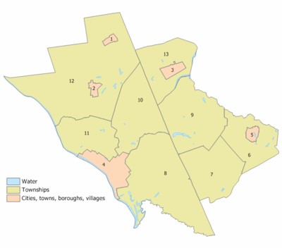
The following municipalities are located in Mercer County. The municipality type is listed in parentheses after the name, except where the type is included as part of the name. Census-designated places and other unincorporated areas are listed under their municipalities.
- East Windsor Township
- Twin Rivers
- Ewing Township
- Hamilton Township
- Mercerville-Hamilton Square
- White Horse
- Yardville-Groveville
- Hightstown (borough)
- Hopewell Borough
- Hopewell Township
- Titusville
- Lawrence Township
- Lawrenceville
- Pennington (borough)
- Princeton Borough
- Princeton Township
- Princeton North
- Robbinsville Township (known as Washington Township until November 2007)
- Robbinsville
- Windsor
- Trenton (city)
- West Windsor Township
- Princeton Junction
History
Founded February 22, 1838, from portions of surrounding counties, Mercer County has a historical impact that reaches back to the pivotal battles of the American Revolutionary War. On the night of December 25, 1776, General George Washington led American forces across the Delaware River to attack the Hessian barracks in Trenton, New Jersey, who did not anticipate an attack near Christmas. Washington followed the assault with a surprise attack on General Charles Cornwallis' forces in the Battle of Princeton on the eve of January 2, 1777, eventually retaking the colony. The successful attacks built morale among the pro-independence colonists.
Mercer County also has the distinction of being the famed landing spot for a fictional Martian invasion of the United States. In 1938, in what has become one of the most famous American radio plays of all time, Orson Welles acted out his The War of the Worlds invasion. His imaginary aliens first "landed" at what is now West Windsor Township. A commemorative monument is erected at Grover's Mill park.[13]
Sports
Mercer County has a number of large parks. The largest, Mercer County Central Park is the home for the US Olympic Rowing Team's training center.[14]
Mercer County is also the home of the minor league baseball team, the Trenton Thunder (Eastern League Double-A affiliate of the New York Yankees), and the minor league hockey team, the Trenton Devils (ECHL Double-A affiliate of the New Jersey Devils.)
External links
References
- ↑ "Find a County". National Association of Counties. http://www.naco.org/Template.cfm?Section=Find_a_County&Template=/cffiles/counties/usamap.cfm. Retrieved 2008-01-31.
- ↑ 2.0 2.1 "QuickFacts: Mercer County, New Jersey". U.S. Census Bureau. http://quickfacts.census.gov/qfd/states/34/34021.html. Retrieved 2007-03-01.
- ↑ 250 Highest Per Capita Personal Incomes of the 3111 Counties in the United States, 2006, Bureau of Economic Analysis. Statistics for year 2006 Accessed May 2, 2008.
- ↑ About Mercer County, 2007, [Mercer County "The Capital County"]. Statistics for year 2007 Accessed March 23, 2008.
- ↑ "New Jersey Resident Population by County: 1880 - 1930". http://www.wnjpin.net/OneStopCareerCenter/LaborMarketInformation/lmi01/poptrd5.htm.
- ↑ "Geostat Center: Historical Census Browser". University of Virginia Library. http://fisher.lib.virginia.edu/collections/stats/histcensus/. Retrieved 2007-03-02.
- ↑ "American FactFinder". United States Census Bureau. http://factfinder.census.gov. Retrieved 2008-01-31.
- ↑ http://factfinder.census.gov/servlet/ACSSAFFFacts?_event=Search&geo_id=05000US34015&_geoContext=01000US%7C04000US34%7C05000US34015&_street=&_county=mercer&_cityTown=mercer&_state=04000US34&_zip=&_lang=en&_sse=on&ActiveGeoDiv=geoSelect&_useEV=&pctxt=fph&pgsl=050&_submenuId=factsheet_1&ds_name=ACS_2007_3YR_SAFF&_ci_nbr=null&qr_name=null®=null%3Anull&_keyword=&_industry=
- ↑ What is a Freeholder?, Mercer County, New Jersey. Accessed March 11, 2008.
- ↑ Meet the Freeholders, Mercer County. Accessed July 4, 2007.
- ↑ New Jersey Presidential Election Returns by County 2004, Eagleton Institute of Politics at Rutgers University. Accessed August 31, 2008.
- ↑ U.S. Election Atlas
- ↑ " War of the Worlds Monument", South Suburban College. Accessed October 17, 2008.
- ↑ "Know, know, know your boat". The Christian Science Monitor. 2008-07-17. http://features.csmonitor.com/backstory/2008/07/17/qrowing/. Retrieved 2008-12-03.
|
|||||||||||||||||||||||
|
|||||||||||||||||
|
||||||||||||||||||||||